
| Home | About Caro-COOPS | Data & Metadata | Modeling Applications | Instrumentation | In the News | Links |
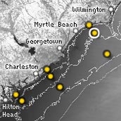
For larger regional interactive map for the Southeast, check the SECOORA interactive map
SUN2 - Sunset Nearshore
|
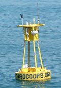 Owned and maintained by USC and UNCW
Buoy Configuration 33.83 N 78.48 W (33 50'52" N 78 29'21" W) 2.9 miles offshore (2.5 nm) |
|
||||
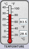
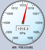
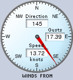
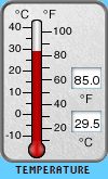
Weather Conditions
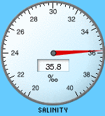
Surface Water Conditions
|
||||||
Disclaimer: These realtime data are considered provisional. Data obtained from the buoy are sent to via satellite to a receiving modem at the University of South Carolina. Data are then processed automatically for viewing on the Web. At no point have the data been reviewed or edited and thus errors from the buoy can and will be displayed online. Errors can occur due to a variety of reasons including biological fouling or physical damage to the sensors. Data are considered provisional and should not be cited. Data are reviewed and checked for accuracy and are available upon request.
All observations for
SUN2 - Sunset Nearshore
Graph DayGraph 3 Days
Graph Week
Graph Month
Graph 3 Months
Graph Year